 Add Row
  Add
Add 


The Storm Approaches: What Does It Mean for Southern California?
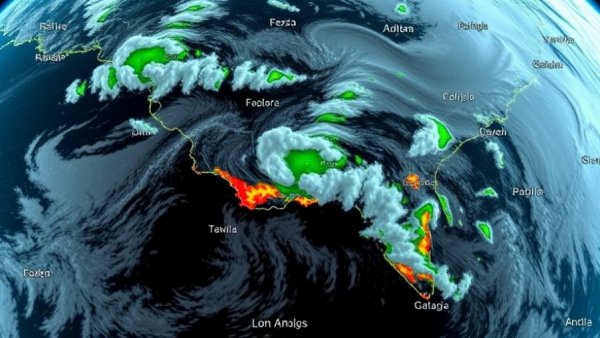
As the atmospheric river event prepares to unleash its intensity on Southern California, residents are feeling the pressure as rainfall levels raise concerns of flash floods and mudslides. Starting Saturday, warnings will be issued across the region, with many residents near burn scars facing immediate risks of debris flows. This storm could lead to unprecedented rainfall amounts for the season, with some forecasts predicting downtown Los Angeles might experience its wettest November since 1985.
Understanding the Risks Ahead
The National Weather Service has issued a flash flood warning for southwestern Los Angeles County until noon Saturday, highlighting the immediate threat posed by the storm. Heavy rainfall is expected to accumulate rapidly, raising the specter of flooding, particularly for small creeks, streams, and urban areas. Communities in close proximity to areas recently impacted by devastating wildfires are under heightened alert due to the potential for dangerous mudslides.
Evacuation warnings are in place for several areas, including the Eaton, Palisades, Canyon, and Hurst burn scars, underscoring the safety measures necessary to protect residents from fast-moving debris. As these dangerously unstable regions prepare for severe weather, city officials are taking proactive steps to inform and evacuate those in harm's way.
Preparing Your Home for the Storm
Residents are urged to ensure their homes are as safe as possible before the storm hits. Begin by securing outdoor items that could be displaced by strong winds and consider moving furniture and décor indoors. It is also essential to prepare an emergency kit that includes food, water, flashlights, batteries, and first-aid supplies. If you have pets, don’t forget to gather their supplies too!
Power outages are likely during the storm, so charge electronic devices fully and have backup chargers available. For those living in high-risk areas, consider obtaining sandbags from distribution sites to minimize the risks of flooding and to redirect rainwater away from your property. The LAFD has advised residents that free sandbags are available for pickup at local fire stations to bolster home defenses.
What to Expect During the Storm
The peak of the storm is predicted to occur Saturday from 3 a.m. to 6 p.m., during which the rainfall could intensify significantly. Forecasters indicate a significant possibility of 0.5 inches of rain falling in just half an hour — a rate capable of triggering debris flows. This spiraling storm presents a unique hazard, echoing the unpredictability that makes it challenging to forecast its trajectory and intensity accurately.
Some areas with recently burned hillsides may be vulnerable to intense mudslides. The speed and force of such flows create an immediate threat to homes and roadways. Experts recommend that residents should take all evacuation orders seriously, particularly in areas designated as high risk.
Making Informed Decisions
As Southern Californians brace for this storm, determining when to act is crucial. Those living near fire-scarred terrains need to stay vigilant. The National Weather Service will provide updates, so residents should frequently check local news outlets to stay informed. Attention should be paid to alerts for your area as these warnings could dictate whether you stay in your home or prepare to evacuate.
Above all, the community's safety is paramount. It’s advised that individuals check in on neighbors, especially elderly or disabled residents, to ensure they are aware of the impending storm and have the necessary supplies and plans in place.
After the Storm: Next Steps for Recovery and Safety
Once the storm passes, it is critical to evaluate the damage and ensure all safety measures are in place as recovery begins. Monitor updates from emergency services for information on road conditions and the safety of returning home. Report any fallen trees or hazardous conditions to local authorities. Also, be mindful of soil saturation levels as these conditions can lead to further risk of landslides in the days following the rain.
With proactive planning and community cooperation, local residents can navigate these challenging weather conditions while keeping their families, pets, and properties safe. If you or someone you know has been affected by previous natural disasters, now is the time to heed weather alerts and take precautionary measures seriously.


Write A Comment